Trail Walking Val de Bagnes - Verbier - Ruinettes via les Shlérondes - Photo

Verbier - Ruinettes via les Shlérondes

 verbier
verbier

User

© OpenStreetMap contributors
Length
Length
10.7 km
Max alt
Max alt
2236 m
Uphill gradient
Uphill gradient
880 m
Km-Effort
Km-Effort  
20 km
Min alt
Min alt
1492 m
Downhill gradient
Downhill gradient
218 m
Boucle
Boucle
No
Creation date :
2014-12-10 00:00:00.0
Updated on :
2014-12-10 00:00:00.0

(0 Reviews)

Walking
Walking
5h30
Difficulty : Unknown

Scan this QR Code to open this trail in the SityTrail application

FREE GPS app for hiking

Logo SityTrail SityTrail

IGN / Geographical institutes

Download SityTrail from the App Store Download SityTrail from Google Play

Logo SityTrail SityTrail World

The world is yours!

Download SityTrail from the App Store Download SityTrail from Google Play Download SityTrail on Huawei AppGallery

About

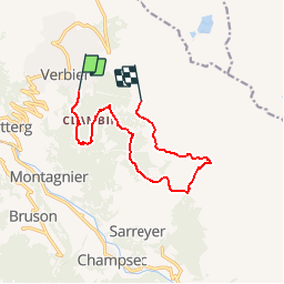
Trail Walking of 10.7 km to be discovered at Valais/Wallis, Entremont, Val de Bagnes. This trail is proposed by verbier.

Description

Ausgangspunkt der Wanderung ist die Talstation des Médran-Kabinenlilfts. Den Parkplatz Richtung Hotel Verbier Lodge überqueren und weiter bis la Dent (35 Min.). Bei der Kreuzung zum kleinen Weiler Clambin (25 Min.) bergan Richtung le Hattey (20 Min.) weitergehen. Im Wald dem Pfad bis zu einem befahrbaren Weg (25 Min.) folgen und dann weiter Richtung Shlérondes (30 Min.). Von dort geht es zur Levron-Suone (50 Min.) und dann der Su-one entlang bis les Ruinettes (45 Min.).

Elevation profile

Points of interest

Point of interest Val de Bagnes -  - Photo
verbier
VAL DE BAGNES 
Point of interest Val de Bagnes -  - Photo
verbier
VAL DE BAGNES 
Point of interest Val de Bagnes - Télécabine - Photo
verbier
VAL DE BAGNES 

Positioning

Country:
Switzerland
Region :
Valais/Wallis
Department/Province :
Entremont
Municipality :
Val de Bagnes
Location:
Unknown
Start:(UTM)
363428 ; 5105927 (32T) N.

Trails nearby

Trail On foot Val de Bagnes - Vollèges - Levron - Photo
On foot
PRO

On foot

Easy
Val de Bagnes, Valais/Wallis, Entremont, Switzerland
3.3 km | 7.8 km-effort
1h 46min
No
Trail On foot Val de Bagnes - Vollèges - Levron - Photo
On foot
PRO

On foot

Easy
Val de Bagnes, Valais/Wallis, Entremont, Switzerland
5.4 km | 10.3 km-effort
2h 20min
No
Trail On foot Val de Bagnes - Ancien Bisse du Levron - Photo
On foot
PRO

On foot

Easy
Val de Bagnes, Valais/Wallis, Entremont, Switzerland
10.7 km | 13.4 km-effort
3h 2min
No
Trail Walking Val de Bagnes - Le Châble – Cabane de Louvie / Jour 2 - Photo
Walking
Greg813

Walking

Difficult
Val de Bagnes, Valais/Wallis, Entremont, Switzerland
12.4 km | 21 km-effort
3h 37min
No
Trail On foot Val de Bagnes - Promenade de la Dranse - Photo
On foot
PRO

On foot

Easy
Val de Bagnes, Valais/Wallis, Entremont, Switzerland
7.1 km | 9.4 km-effort
2h 8min
No
Trail On foot Val de Bagnes - Bruson - Moay - Photo
On foot
PRO

On foot

Easy
Val de Bagnes, Valais/Wallis, Entremont, Switzerland
3.6 km | 10 km-effort
2h 16min
No
Trail Walking Riddes - Croix de Coeur - Pierre Avoi - Photo
Walking
jptritten

Walking

Medium
(2)
Riddes, Valais/Wallis, Martigny, Switzerland
6.4 km | 10.9 km-effort
2h 26min
Yes
Trail On foot Isérables - Le Rosey - Taillay - Photo
On foot
PRO

On foot

Easy
Isérables, Valais/Wallis, Martigny, Switzerland
4.4 km | 5.7 km-effort
1h 18min
No
Trail On foot Sembrancher - Chemins pédestre, commune de Sembrancher - Photo
On foot
PRO

On foot

Easy
Sembrancher, Valais/Wallis, Entremont, Switzerland
4.9 km | 11.3 km-effort
2h 34min
No


Close
My subscriptions